
ESSO - Indian National Centre for Ocean Information Services
(An Autonomous Body under the Ministry of Earth Sciences, Govt. of India)
IOCINDIO Training cum Workshop
Coastal Vulnerability due to sea level rise and Storm Surges
during 27 - 31 May, 2019
Global climate change and the threat of accelerated sea-level rise exacerbate the already existing high risks of storm surges, severe waves and tsunamis in coastal areas. Climate change may not only enhance the most threatening extreme events but also aggravate long-term biogeophysical effects, such as sea-level rise, shoreline erosion, sediment deficits, saltwater intrusion into coastal aquifers and the loss of coastal wetlands. In light of these existing hazards and increasing risks in coastal regions, there is a great need to gain as much insight as possible into the exact nature and extent of possible risk increases related to future climate trends.
In view of the looming threats due to climate change and the ever increasing need to mitigate and manage coastal hazards it is imperative to develop expertise among the coastal stake holders and especially the government officials on the tools and techniques available to model and map the coastal vulnerability arising out of hazards such as sea level rise, storm surges, urban flooding, tsunamis etc.
This training programme on "Coastal Vulnerability due to sea level rise and Storm Surges" will be an an even mixture of theory, practical and field sessions wherein trainees are encouraged to work independently on GIS, Image Processing software, design field data collection programmes and run numerical models on coastal hazards. Both open source and commercial GIS and Image Processing software are used in the practical sessions.
The trainees will be taught about field data collection using GPS, satellite image processing, development of a spatial database in GIS, spatial analysis and interpretations of results for preparation of hazard maps for management purpose using case studies.
- Climate change, projections and impacts
- Coastal Risk & Vulnerability - Introduction
- Sea Level Rise and its impact
- Storm surge modelling and mapping
- Coastal urban flooding
- Coastal Inundation mapping
- Tools, Instrumentations for field data collection
- Coastal Vulnerability indices
- Climate database and its utilization
- Field Data Collection
- Basics of GIS and Remote Sensing - 1
- Field data collection and mapping - 1
- Storm Surge Modelling - 1
- Coastal Flooding -1
- Generation of Coastal Vulnerability Index - 2
- Last date for online application: 13th May , 2019
- Course Date: 27 th - 31st May, 2019
Climate Change protocols - impact-based solutions

Interested candidates are encouraged to apply for the course online using the link provided https://www.incois.gov.in/ITCOocean/login.jsp. on or before 13th May , 2019 @ IST 05:00PM.
The faculty for the course consists of scientists/experts in different fields from member countries of IOCINDIO along with experts from the premier Institutes of the Country including NIOT, NCCR and INCOIS.
The tentative schedule of the training programme is given below:
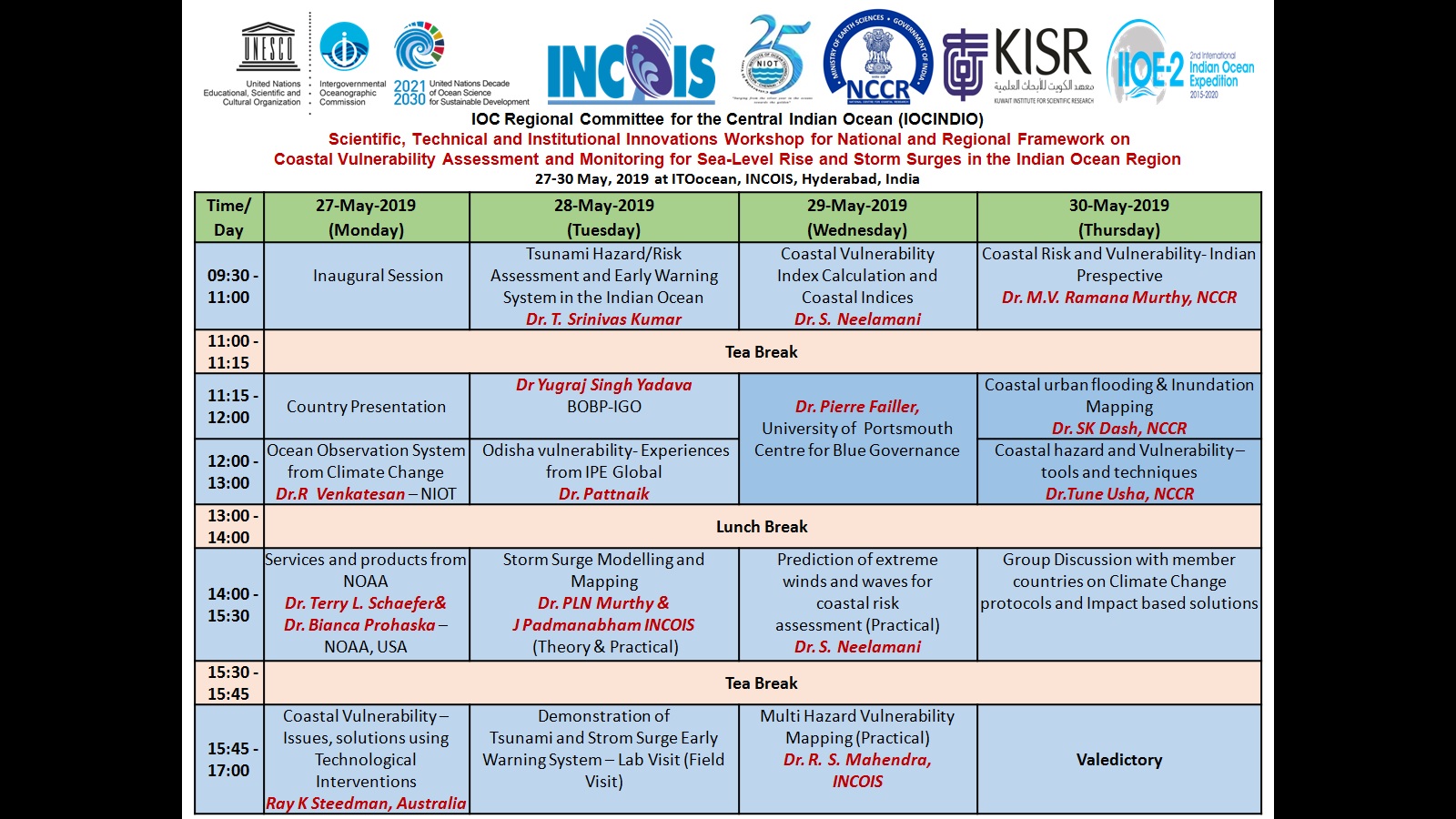

Photo Gallery


