
ESSO - Indian National Centre for Ocean Information Services
(An Autonomous Body under the Ministry of Earth Sciences, Govt. of India)
Ocean State Forecast
Among the Indian Ocean rim countries, India is endowed with a very long coastline of over 7500 km (including Andaman, Nicobar and Lakshadweep Islands). With the Arabian Sea to the west and the Bay of Bengal to the east and the vast expanse of the Indian Ocean to the south, a wide range of marine activities dominate the maritime zone of India. Prior information on the state of the seas surrounding the Indian subcontinent is vital for the smooth operational activities not only for hose who are venturing out into the sea but also for those at the sea shore. The users can take appropriate informed decisions based on the forecast sea state conditions, saving life and property. There is thus an inherent economic benefit to the users of the ocean state forecast information. The type of activities that takes place along the coastline is also very diverse, varying from traditional fishing to high tech oil exploration. Dotted along the Indian coastline are numerous ports (both major and minor) which have contributed greatly to the economic growth of the country; most of the major ports are located along large coastal cities. For the efficient operation of these ports, one critical factor is information on sea state parameters in the vicinity, like locally generated wind waves, remotely generated swell waves, currents, winds and tides. The entry and exit of the vessels to the port, be it a small fishing boat or a huge oil tanker is governed by these factors and prior knowledge of these parameters will greatly help the operations at the port. Even offshore port activities like Single Point Mooring operations, which is a loading buoy anchored offshore, that serves as a mooring point and interconnect for large tankers loading or offloading gas or liquid products to the shore based facilities requires accurate sea state information.Another subtle application of sea state forecast information is recreational tourism at the sea side, including the operations of sea planes, recently introduced at some locations along the Indian coastline. Marine activities in the seas around India, is not restricted to port activities alone and ranges from conventional fishing to high-tech oil-natural gas-mineral explorations; transportation of goods, marine research, and defence activities. Further, this information is important during contingencies like search and rescue operations in the sea and oil spills. During cyclones and other extreme situations, based on the forecast information, alerts are issued to the general public as well as the administrators of the coastal stretch under risk so that that the population under threat is relocated to safer places.
Forecasting of oceanographic parameters (both surface and subsurface) at different time scales is thus extremely important for a wide spectrum of users ranging from fishermen to offshore industries. Keeping this in mind, Earth System Science Organisation - Indian National Centre for Ocean Information Services (ESSO-INCOIS) established the integrated INDian Ocean FOrecasting System (INDOFOS), capable of predicting the surface and subsurface features of the Indian Ocean reasonably well in advance (5 to 7 days presently).
At present, INCOIS provides forecasts of
- Height, direction and period (of both wind waves and swell waves).
- Sea surface currents.
- Sea surface temperature.
- Mixed Layer Depth (the well mixed upper layer of the sea).
- Depth of the 20 degree isotherm ( a measure of the depth of the thermocline).
- Astronomical tides.
- Wind speed and direction.
- Oil-spill trajectory
ESSO-INCOIS provides the ocean state information not only to all the sea faring communities like the fishermen, Indian Navy, Indian Coast Guard, merchant and passenger shipping agencies, offshore oil & gas exploration agencies , research organisations but also to other coastal communities. The forecast is available separately for the following regions: Arabian Sea, Bay of Bengal, Northern Indian Ocean, Southern Indian Ocean, Red Sea, Persian Gulf and South China Sea. Further, it provides more detailed forecast information for specific locations like fish landing centres, small fishing harbours, commerical ports, etc. as well as for the coastal waters of the maritime states, union territories and island regions of India.
The Operational Models used for Ocean State Forecasting by INCOIS View TableThe forecasts are generated by a suite of state-of-the art numerical models, which are customized to simulate and predict the Indian Ocean features accurately. The models used are I) WAVEWATCH III, MIKE and Regional Ocean Modeling System (ROMS) and General NOAA Oil Modeling Environment (GNOME). Atmospheric forecast products from different meteorological forecasting agencies (NCMRWF and ECMWF) are used for forcing these models in the forecast mode. Global forecast and deep sea forecasts, differ mainly in spatial and temporal resolution of the forecast, extent of validations carried out, etc. In coastal forecast, the models are set up using the concept of 'multiple grid' with coarse resolution in the open ocean region and very fine resolution for the specified coast, providing more accurate data at the coast. These forecasts are generated operationally using the latest Information and Computational Technology tools and run on High Performance Computers.
The products: Major user-customized OSF services/products by INCOIS View Table
The validation
For testing the accuracy and reliability of the model products, in-situ and satellite measurements (near shore wave rider buoys, deep sea buoys, ship borne wave height meters and other deep sea met-ocean buoys as well as Automatic Weather Stations) are used for the purpose of validation. Validation is done routinely for the different seasons as well as during the extreme conditions (e.g. cyclones). Near real time validation is carried out for site-specific forecast as well as based on satellite passes over the Indian Ocean region.
ESSO-INCOIS, Hyderabad is the only operational agency for the Indian Ocean region providing detailed forecast information for the Indian Ocean. It has been possible to provide this service because of the high end computing infrastructure available at INCOIS, along with access to data from shallow and deep sea met-ocean measuring systems deployed in the sea, connected real time through satellites. All the services to the public are released after thorough in-house validation of the data, using these measuring systems, along with other remotely sensed satellite data. To further enhance the quality of this forecasting system, ESSO-INCOIS plans to expand the Wave Rider Buoy network ensuring that a minimum of two Wave Rider Buoys are deployed along each Indian state (including the island territories). It also proposes to increase the deployments of Ship-mounted Automatic Weather Stations to 100 in number these data will be assimilated in real time in the numerical models.
The dissemination
Eventhough the primary dissemination mode is the INCOIS website, it also provides these services through other modes like e-mail, mobile phones, TV, Radio and Electronic Display Boards to all the Stakeholders. The Information and Communication Technology tools have been exploited to the maximum for providing in-time quality forecasts to the users. Further, there is strong collaboration with NGOs and coastal research centres as well as universities, for further dissemination. In areas with no electricity supply or with serious power issues, the dissemination is by Manual Display Boards (e.g. Sundrabans region) and Black Boards at other fish landing centres.
Taking into consideration the specific requirements of the various users, new products have been developed and customised like forecast along the ship tracks, web map services and forecast for ports and harbours. The High Wave Alert service is another important and popular service of INCOIS issued during cyclones (web statistics during Phailin, October, 2013) and other extreme events.
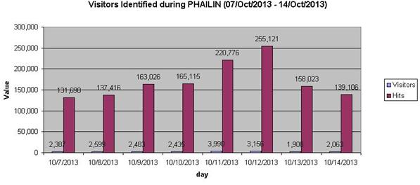
Figure INCOIS- Ocean State Forecast page web statistics during the period October 7 - 14, 2013
Emergency services for conducting search and rescue operations and combating oil spills have also being developed to support the users during such critical situations.
The users
Our users include fisher and coastal populations, Maritime Boards, Indian Navy, Indian Coast Guard, Shipping sector, Energy Sector, Oil & offshore exploration industries, Port Authorities. Pollution Control Boards. Disaster Management Agencies, NGOs and other research organisations.
Feedback
The feedback of the users is collected routinely, through mail, telephone and user interaction meetings at coastal locations as well as at INCOIS, for improving the dissemination system. User awareness and interaction workshops are held along the coastal belt to advise the fishermen and improve the quality of the system, taking their needs into consideration.
=============================================================
Disclaimer: The forecast products and the conclusions drawn thereof are mainly based on different numerical models being run at INCOIS. The forecasts are evaluated routinely for different locations, where observational data sets are available. However, the forecast quality has not been endorsed at other places where in-situ instrumental observations are presently not available.
==============================================================

