
Ocean surface waves are integral to various human activities at sea, including shipping, fishing, offshore operations, coastal protection, and recreation. The accurate prediction of wave conditions is crucial for these activities, necessitating the use of advanced numerical wave models as indispensable tools. The primary objective of the INCOIS wave modelling system is to provide the best global wave forecasts, with a particular emphasis on the Indian Ocean.
WAVEWATCH III (WW3), a third-generation wave model developed at NOAA/NCEP and later made available on GitHub (https://github.com/noaa-emc/ww3), is a community wave modelling framework that integrates the latest advancements in wind-wave modelling and dynamics.
The operational wave forecasting systems at INCOIS are based on the WW3 model. INCOIS has been utilizing the WW3 spectral wave model for global wave forecasting (operating version 6.07) since 2014.
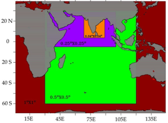 INCOIS WW3 model nested domains
These nested grids facilitate two-way interactions among them, enhancing the accuracy of wave forecasts. The WW3 model employs the ST4 physics package to parameterize input and dissipation source terms.
The forecasting system integrates 10 m analysis and forecasts wind components from the European Centre for Medium Range Weather Forecasting (ECMWF) and the National Centre for Medium Range Weather Forecasting (NCMRWF) as forcing fields. ECMWF winds are available at 3-hour intervals with a resolution of 0.250 × 0.250 degrees, while NCMRWF winds are available at 6-hour intervals with a resolution of 0.125 × 0.125 degrees.
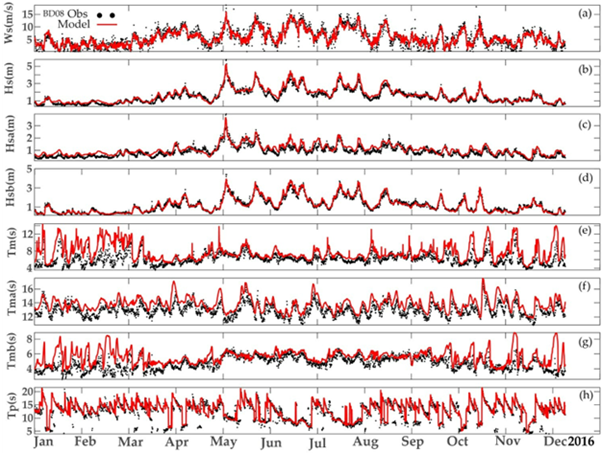
The operational model at INCOIS runs once daily at 0000 UTC and generates forecasts for the subsequent 10 days. It has been extensively tested and tuned to accommodate various wave conditions specific to the Indian Ocean (Remya et al. 2016; Remya et al. 2020; Raj et al., 2023). INCOIS operates three different forecast runs daily: Run 1 uses ECMWF winds as forcing fields, Run 2 uses NCMRWF winds, and Run 3 incorporates a data assimilative system.
In 2020, INCOIS upgraded its wave forecasting system by implementing an optimal interpolation (OI) technique to assimilate significant wave height (SWH) observations from altimeters aboard SARAL/AltiKa, Jason-2, and Jason-3 satellites (Seemanth et al. 2021). Further enhancements in 2022 incorporated SWH observations from deep and shallow water buoys in the North Indian Ocean region, alongside satellite data from SARAL/AltiKa, Jason-3, Sentinel-3a, and Sentinel-3b (Seemanth et al. 2024).
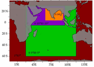 INCOIS WW3 Data assimilative model nested domains
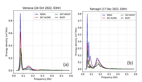 Comparison of 1-dimensional model spectra from data assimilative model to the buoy observed spectra at (a) Versova and (b) Ratnagiri
This setup allows for improved wave height forecasts, with satellite data assimilation enhancing SWH predictions by up to ~16% initially, and buoys contributing to an additional improvement of ~43% in early forecast hours. The impact persists throughout the forecast period, demonstrating significant enhancements in wave height and wind-sea height predictions.
The INCOIS WW3 model, through its advanced configurations and data assimilation techniques, stands as a robust tool for providing accurate and reliable global wave forecasts, particularly tailored for the Indian Ocean region.


