High-resolution Operational Ocean Forecast and reanalysis System (HOOFS)
HOOFS
Accurate forecasts of specific oceanographic parameters—such as currents, temperature, and salinity in both surface and subsurface ocean layers, as well as tides and wind waves—are crucial for planning most maritime activities and ensuring the safety and livelihoods of millions who venture into the ocean. The users of operational ocean forecasts range from traditional fisherfolk to high-tech maritime industries. Recognizing the importance of precise predictions, particularly for the waters around India, the Ministry of Earth Sciences (MoES), Government of India, tasked the Indian National Centre for Ocean Information Services (INCOIS) with designing, developing, and operating a comprehensive, high-resolution ocean forecast and analysis/reanalysis system. This initiative led to the creation of the High-Resolution Operational Ocean Forecast and Reanalysis System (HOOFS), the operational ocean forecast system of India.
Brief History of HOOFS Development
In January 2010, INCOIS began issuing basin-scale forecasts for various oceanographic parameters, including sea surface temperature (SST), mixed layer depth, surface currents, and the depth of the 20°C isotherm. These forecasts were based on a relatively low-resolution (1/4°) configuration of the Regional Ocean Modeling System (ROMS) for the Indian Ocean, known as the "Indian Ocean Forecast System" (INDOFOS). This system operated on an in-house high-performance computing (HPC) facility with a computing capacity of 7.1 TF.
However, the system had significant limitations, including low spatial resolution and the absence of a data assimilation system to initialize the forecast model. Without data assimilation, the "ocean analysis" relied solely on a free-running model forced with atmospheric analysis, and the initial conditions for each daily forecast were derived from the previous day's ocean analysis. The open boundary conditions at the southern and eastern edges were relaxed to climatological tracer and geostrophic velocity fields, and tides were not incorporated into the system. The model was driven by 6-hourly atmospheric forecast fields from the GFS configuration of NCMRWF, with a resolution of 1/4°. In March 2012, the spatial resolution of INDOFOS was improved to 1/8°.
To create a more comprehensive operational forecast system featuring high-resolution ocean general circulation models with realistic open boundary conditions and data assimilation schemes, INCOIS initiated the HOOFS project in 2012. This project, planned for a five-year period (2012-2017), was succeeded by the "Ocean Modeling Data Assimilation and Process Specific Observations" (O-MASCOT) project, which ran from 2017 to 2020. The success of these projects was facilitated by the availability of advanced HPC facilities, initially providing about 125 TF of capacity at the Indian Institute of Tropical Meteorology (IITM), Pune, and later expanding to about 930 TF at NCMRWF. These resources were dedicated to the research and development efforts of the HOOFS project, enabling significant advancements in ocean forecasting capabilities.
Design of HOOFS
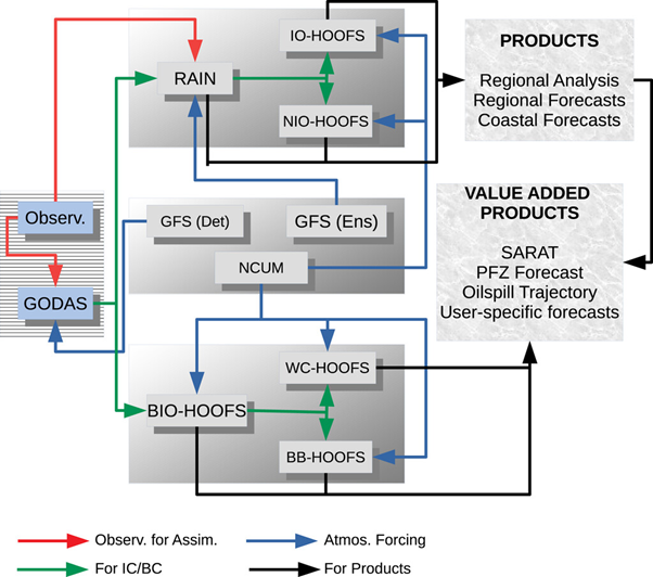
HOOFS is configured with ROMS (version 3.7) utilizing two different horizontal resolutions and a data assimilation scheme. ROMS is a free-surface, terrain-following general circulation model developed by Rutgers University, New Jersey, that solves a set of primitive equations in an orthogonal curvilinear coordinate system. HOOFS consists of two discrete systems - IO-HOOFS and NIO-HOOFS.
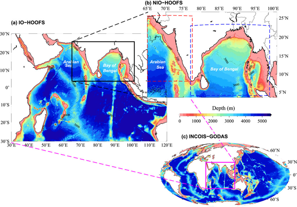
IO-HOOFS (Indian Ocean): Covers the entire tropical Indian Ocean with a spatial resolution of 1/12° (∼9.2 km).
NIO-HOOFS (Northern Indian Ocean): Covers part of the Arabian Sea (east of 65°E) and the entire Bay of Bengal with a higher spatial resolution of 1/48° (∼2.3 km).
Both configurations have 40 sigma levels in the vertical. Bathymetry for these models is prepared from modified ETOPO2 data. Lateral boundary conditions for IO-HOOFS are extracted daily from the INCOIS-Global Ocean Data Assimilation System (GODAS), which covers the global ocean. Lateral boundary conditions for NIO-HOOFS are extracted from Regional Analysis of Indian Ocean (RAIN) which assimilates in situ temperature and salinity profiles and satellite-measured sea surface temperature (SST) and sea level anomaly (SLA) data. More details about the configuration can be found on the RAIN webpage. Tracer, momentum, and sea surface height anomaly fields of NIO-HOOFS are initialized using the regional analysis for January 1, 2017. In both configurations, sea surface salinity fields are relaxed to monthly climatology based on the World Ocean Atlas 2009.
Both NIO-HOOFS and IO-HOOFS use the K-profile parameterization (KPP) scheme for vertical mixing. For horizontal mixing of momentum and tracers along geopotential surfaces, a harmonic mixing scheme is employed, and a bulk parameterization scheme is used for computing air-sea fluxes of heat in both IO-HOOFS and NIO-HOOFS configurations. Forecasted atmospheric fields from the National Centre for Medium Range Weather Forecasting (NCMRWF) Unified Model (NCUM) with a horizontal resolution of 12 km force both NIO-HOOFS and IO-HOOFS setups.
Tidal forcing is introduced in NIO-HOOFS, with boundary conditions in the southern and western open boundaries forced by 10 major tidal constituents extracted from the TPXO 7.0 model.
Design of HOOFS Configuration
Domains of the model configurations in the HOOFS setup
HOOFS: Generation of Forecasts
The primary products of HOOFS are the daily analyses and forecasts of ocean general circulation parameters. The high-resolution operational ocean forecast for the coastal waters around India was established primarily due to requests from the user community, which includes fishermen, the Coast Guard, the Navy, and maritime industries. In addition to ocean analysis and forecasts on various oceanographic parameters, HOOFS also prepares and disseminates specific, tailor-made products to meet the needs of these users, either regularly or on demand. User feedback on the usefulness of these products and suggestions for improvement are collected directly, and regular user interaction meetings are organized by INCOIS with the help of non-governmental organizations working among fishing communities.
The entire operational process is fully automated, from receiving processed ocean observations and atmospheric forcing from NCMRWF to the quality checks, integration of models, and the generation and dissemination of analysis, forecast, and value-added products. The preparation of ocean analysis starts at 0930 IST (UTC + 05:30) daily with the reception of processed ocean observations from NCMRWF, followed by atmospheric forcing data, which includes 6-hourly analysis for the previous day from the NCUM (deterministic) and GFS models (both deterministic and 80-member ensemble) and 6-hourly forecasts for the subsequent five days from NCUM. After quality checks, the integration of GODAS produces a global ocean analysis, from which the southern and eastern boundary conditions for the integration of RAIN are extracted. This is followed by the integration of the 80-member RAIN system, with the ensemble mean used to provide initial conditions for the integration of IO-HOOFS, generating forecast products for the Indian Ocean basin. The integration of NIO-HOOFS follows IO-HOOFS, with southern and western boundary conditions for NIO-HOOFS extracted from RAIN (for the past five days) and IO-HOOFS forecasts (for the next five days). NIO-HOOFS uses atmospheric fluxes computed from the atmospheric analysis of NCUM for the previous five days and 6-hourly forecasts for the subsequent five days from NCUM. Since NIO-HOOFS does not assimilate data, it is scheduled to reinitialize every two years using initial conditions from RAIN to avoid significant drift from the observed state. This reinitialization involves integrating the model for at least six months to ensure sufficient spin-up before starting forecast runs.
Daily, 3-hourly forecasts of ocean circulations for the subsequent five days are generated based on simulations from both IO-HOOFS and NIO-HOOFS. Forecasts of physical parameters in the coastal waters and the Indian Ocean are prepared based on simulations from NIO-HOOFS and IO-HOOFS, respectively. General forecasts of parameters such as sea surface temperature (SST), mixed layer depth, surface currents, and the depth of the 20°C isotherm are regularly prepared from the model forecast fields, with their images and data posted on the Ocean State Forecast (OSF) services webpage of INCOIS (Click here).
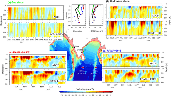
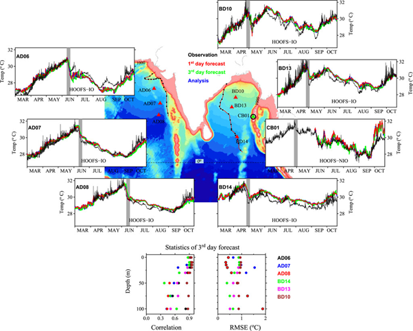
Surface and subsurface currents from HOOFS are compared with observations
Validation of various forecast parameters from HOOFS with observation
Reference: Francis et al. (2020), High-Resolution Operational Ocean Forecast and Reanalysis System for the Indian Ocean, Bulletin of Amer. Meteorol. Soc. https://doi.org/10.1175/BAMS-D-19-0083.1
Indian National Center for Ocean Information Services (INCOIS)