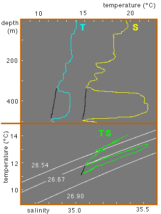
 Temperature and salinity as functions of depth
and temperature-salinity (TS-) diagram at a station on the east Australian
continental slope. The undercurrent of Bass Strait
Water is indicated by the high salinity and temperature at 350 - 450 m depth. In the TS-diagram the presence of Bass Strait Water is indicated by a thin wedge that follows a level of constant density. (Selected constant density curves (isopycnals) are shown in white.) Stations without Bass Strait Water presence display properties indicated by the black lines. See Figure 9.7 for the location of the station.
Adapted from Tomczak (1985).
Temperature and salinity as functions of depth
and temperature-salinity (TS-) diagram at a station on the east Australian
continental slope. The undercurrent of Bass Strait
Water is indicated by the high salinity and temperature at 350 - 450 m depth. In the TS-diagram the presence of Bass Strait Water is indicated by a thin wedge that follows a level of constant density. (Selected constant density curves (isopycnals) are shown in white.) Stations without Bass Strait Water presence display properties indicated by the black lines. See Figure 9.7 for the location of the station.
Adapted from Tomczak (1985).
contact address: