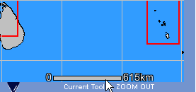
The map image contains a scale bar in the lower right-hand corner for reference. The scale bar is of fixed length and represents a specified distance within the map. As the map is zoomed in or out, the scale bar will not change, but the distance it represents will. Due to the wide array of monitors, resolutions, and pixel dimensions of users’ computers, the scale bar is presented only as a general reference and is not entirely accurate. In the example below, the scale bar represents a distance of 615 kms in the map image. See cursor location in the following image.