22. Indian Ocean ITF
Robert Molcard
INSTANT is a coordinated international effort to measure the flow of water between the Pacific and Indian Oceans via the Seas of Indonesia [Figure 1]. It is essential that this so-called Indonesian Throughflow (ITF) be properly measured, as it will lead to a much improved understanding of the large-scale climate system, specifically the climate affecting the Maritime Continents of the Indonesian region.
In the past, measurements programs of the ITF lacked temporal coherence: the data covered different time periods and depths in the different passages of the complex pathways leading to the Indian Ocean. This has lead to ambiguity of the mean and variable nature of the ITF, and the transformation of the thermohaline and transport profiles within the interior seas. INSTANT is designed to provide a time series of ITF transport and property fluxes, and their variability from intraseasonal to annual time scales, along the ITF pathway from the intake of Pacific water at Makassar Strait and Lifamatola Passage, to the Lesser Sunda exit channels into the Indian Ocean.
The international INSTANT program combines a moored array with supporting observational networks, thus enhancing the value of each individual measurement. The objective is to understand the broad spectrum of variability in the ITF, and the role of regional oceanography in establishing the transfer function between the Pacific inflow and the outflow into the Indian Ocean. The international group of scientists and their respective responsibilities as part of the INSTANT program are listed in Table 1. Many of the supporting measurements of the INSTANT program, such as the JAMSTEC Mindanao Current mooring, the multi-year time series from the Indonesian tide gauge and meteorological network, and the Australian XBT program, already exist and are ongoing. Table 1 also includes an important contribution to the INSTANT objectives for regional CTD and ADCP observations during the INSTANT mooring period, to be undertaken by P2O-LIPI (Research Center of Oceanography-LIPI).
The characteristics of the ITF and the locations of the INSTANT moorings are given in Figure 1.The initial deployment of all moorings will be in the August to October 2003 time frame, with re-deployment around February 2005, and recovery in July 2006. Table 2 provides more information of the location and type of instruments to be deployed on the INSTANT moorings.
The INSTANT program within the Seas of Indonesia includes Australia, France, Indonesia, The Netherlands, The United States of America, and with the Mindanao mooring, Japan.
| ||||||||||||||||||||||||||||||||||||||||||||||||||||||
| ||||||||||||||||||||||||||||||||||||||||||||||||||||||||||||||||||||||||||||||||||||||||||||||||||
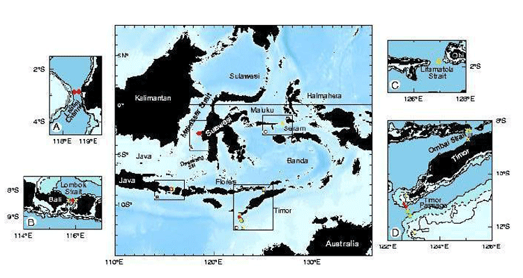
Figure1:Schematic of Indonesian Throughflow pathways (Gordon, 2001). The solid arrows represent North Pacific thermocline water; the dashed arrows represent South Pacific lower thermocline water. Transports in Sv (106m3s-1) are given in red. The 10.5 Sv in italics is the sum of the flows through the Lesser Sunda passages. ME is the Mindanao Eddy; HE is the Halmahera Eddy. Superscript refers to reference source: 1: Makassar Strait transport in 1997 (Gordon et al., 1999); 2: Lombok Strait (Murray and Arief, 1988; Murray et al., 1989) from January 1985 to January 1986; 3: Timor Passage (between Timor and Australia) measured in March 1992 to April 1993 (Molcard et al., 1996); 4: Timor Passage, October 1987 and March 1988 (Cresswell et al., 1993); 5: Ombai Strait (north of Timor, between Timor and Alor Island) from December 1995 to December 1996 (Molcard et al., 2001); 6: between Java and Australia from 1983 to 1989 XBT data (Meyers et al., 1995; Meyers, 1996); 7: Upper 470 m of the South Equatorial Current in the eastern Indian Ocean in October 1987 (Quadfasel et al., 1996); 8: Average ITF within the South Equatorial Current defined by 5 WOCE WHP sections (Gordon et al., 1997). The hollow arrow represents overflow of dense Pacific water across the Lifamatola Passage into the deep Banda Sea, which may amount to about 1 Sv (van Aken et al., 1988). The 100, 500, and 1000 m isobaths are shown in the inserts.
serts A-D show positions of INSTANT moorings. Insert A: 2 Makassar Strait Inflow moorings (U.S., red diamond) within Labani Channel. Insert C: Netherlands mooring within the main channel of Lifamatola Passage (yellow triangle). Insert B, D: Sunda moorings in Ombai Strait, Lombok Strait, and Timor Passage (U.S., red diamonds; France, purple square; Australia, green circles). The positions of the shallow pressure gauge array (U.S., green X).
An important contributing mooring is shown by the open red circle (exterior to Indonesian waters) in the Mindanao Current (ME) represents an ADCP mooring deployed since September 2000, as part of JAMSTEC's Tropical Ocean Climate Study (TOCS) program.