|
1
|
|
|
2
|
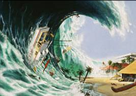
- A system of ocean gravity waves formed as a result of large-scale
displacement of sea surface. Can travel long distances without losing
energy.
- Length and Time Period
- Long wave length (of several 100
km)
- Periods of a few minutes to about an hour
- Speed proportional to square root of water depth
- 500 to 1000 km per hour in Deep Ocean
- About 30 km per hour near shore
- Height of Tsunami Wave
- Less than a metre in the Deep Ocean
- Grows to Tens of metres near shore
|
|
3
|
|
|
4
|
- coordinate IOTWS;
- promote establishment and development of national tsunami warning and
mitigation capacities;
- facilitate exchange of seismic, sea level data;
- promote sharing of experience and expertise related to tsunami warning
and mitigation;
- liaise with other tsunami warning systems; and relevant organizations,
programmes and projects;
- promote capacity-building
- promote tsunami research
|
|
5
|
- Based on joint operation of international networks of detection
connected with national tsunami warning centres
- High-level commitment by country with UN governance provided under the
IOC
- Each nation is responsible for issuing warnings in their territory and
for protecting its own population.
- National centres must have strong links with emergency preparedness
authorities (national, provincial and local)
|
|
6
|
- WG1: Seismic measurements, data collection and exchange
- WG2: Sea level data collection and exchange, including
DART
- WG3: Risk assessment
- WG4: Modelling, forecasting and scenario
- development
- WG5: System of interoperable advisory and
- warning centres
- WG6: Mitigation, preparedness and response
|
|
7
|
|
|
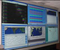
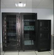
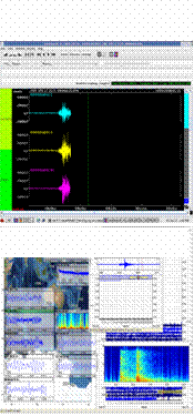
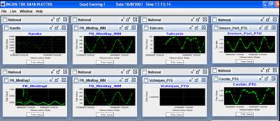
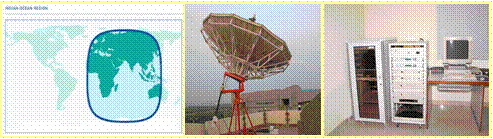
8
|
- Tsunami Warning Centre
- Numerical Modelling
|
|
9
|
|
|
10
|
|
|
11
|
|
|
12
|
|
|
13
|
|
|
14
|
|
|
15
|
|
|
16
|
|
|
17
|
|
|
18
|
|
|
19
|
|
|
20
|
|
|
21
|
|
|
22
|
|
|
23
|
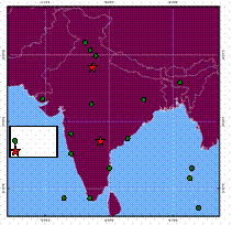
- Understanding Tectonics
- Continuous monitoring and recording of the earthquakes
- characterizing the lithospheric deformation
- 3D Seismic mapping
- NGRI, NCAOR, INCOIS…
- History of tsunami
- Stratigraphy record of paleo-tsunami deposits,
- Identification, mapping and dating fossil micro-atoll surfaces
- OSL and radiocarbon dating,
- PRL, IISC, NGRI, IITs, Universities……
|
|
24
|
|

 Notes
Notes