Swell consists of waves generated by a distant storm that travel over the ocean's surface as free waves away from the storm region. The tropical and subtropical South Pacific Ocean is under the Trade Wind regime, a system of very steady winds with infrequent storms (the exception being the occasional cyclone).
Most swell travelling through that region is generated outside the Trade Wind zone by the storms of the temperate regions. Close to the region of its formation it spreads in a circular fashion, but by the time it reaches the Trade Wind zone it has covered such a large distance that it arrives with straight parallel crests.
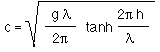
The speed c of ocean surface waves is given by
where g is the acceleration of gravity (the force that controls the dynamics of the waves), h is the water depth and l the wavelength. p is the constant "pi" equal to 3.1416.
The equation can be simplified for the two cases of deep and shallow water:
A: Deep water wave speed (short waves; depth is larger than 1/2 of the wavelength) |
 |
B: Shallow water wave speed (long waves; depth is less than 1/20 of the wavelength) |
 |
In the open ocean where the water is deep swell falls into the first category, so its speed is independent of the water depth. (h does not occur in the equation of case A.) The animation below shows swell, indicated by its parallel wave crests, approaching a small circular island. As the swell impinges on the island's coastline it is reflected and produces a new circular swell pattern. A canoe travelling through the region experiences the two crossing swell systems and can identify the island's location by the angle between the two swell systems.
Because the energy of the reflected swell is distributed in circular fashion the reflected waves decrease in height as they travel away from the island. By the time they travelled for 20 - 30 nautical miles (35 - 80 km) they can no longer be detected. Every island has therefore a ring of reflected swell around it, which can be used for navigation when the canoe is within some 20 nautical miles of the island.

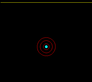
The other navigational aid is swell refraction. This phenomenon occurs where islands are surrounded by shallow water. In shallow water the swell changes from a deep water wave to a shallow water wave, so its speed becomes dependent on water depth h (case B.) Because the depth decreases from the ocean to the island the swell speed decreases as the island is approached. As a result the wave front in the vicinity of the island lags behind the wave front in the open ocean.
The animation below shows how as the result of the different wave speed in deep and shallow water the swell "curls around" the island and produces a wave shadow behind it. The red lines are depth contours; they indicate how the water depth changes from deep water to shallower and shallower water as the island is approached. In the deep water the swell runs uniformly across the ocean; over the shallow water it is slowed down, which produces the curling effect. A canoe approaching the island from the side of the shadow zone will notice the disappearance of the swell and use this information to home in on the island.
Real islands show a combination of reflection and refraction of various degrees depending on the size and shape of the island and the topography around it. But a skilled navigator will always pick up the changes in the swell pattern and use them to navigate. He may even know the particularities of swell patterns of individual islands.