Western boundary current of the North Atlantic Ocean.
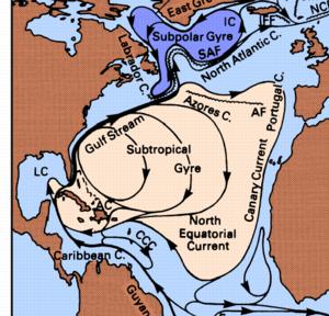
The ocean currents of the subtropical climate zones form closed "gyres" that span entire ocean basins. In the North Atlantic Ocean this "Subtropical Gyre" consists of the North Equatorial Current, the Gulf Stream, the North Atlantic Current and the Azores, Portugal and Canary Currents (Godfrey and Tomczak, 2003):
Like all western boundary currents the Gulf Stream is much swifter than currents in the central and eastern ocean basins (typically 4 knots or 7 km/h, compared with 0.5 knots or 0.9 km/h outside the western boundary current). It can thus have a significant impact on the speed of vessels, which typically reach sailing speeds of 10 - 15 knots (18 - 25 km/h).
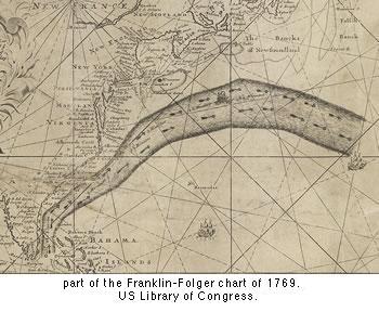
Timothy Folger drew a chart of the Gulf Stream, which was edited and published by Benjamin Franklin. It showed the current as a stream of warm water from the Gulf of Mexico that crosses the Atlantic Ocean:
Today the Gulf Stream is monitored via satellites that sense the sea surface temperature. The satellite data allow the daily construction of temperature maps, in which the Gulf Stream is seen as a band of warm water coming out of the Strait of Florida and pushing into the colder water of the northern regions:
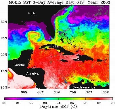
The satellite image shows that the real Gulf Stream does follow the general path imagined by Folger and Franklin but is not a smooth band of warm water. It develops eddies, filaments and instabilities. A prominent feature seen in the Gulf of Mexico is the "Loop Current," a circular intrusion into the Gulf that develops on occasions. Another eddy is seen as a bluish spot in the region where the Gulf Stream pushes along the USA east coast.
Godfrey, J. S. and M. Tomczak (2003) Regional Oceanography: an Introduction 2nd ed. Daya Publishing House, Delhi.