 This figure shows the drift of the buoy. The buoy had a subsurface drogue
attached and therefore served as an indicator of water movement for the
upper mixed layer.
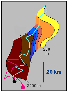
This figure shows the drift of the buoy. The buoy had a subsurface drogue
attached and therefore served as an indicator of water movement for the
upper mixed layer.Black contours and colours indicate water depth, contouring interval is 250 m. Thick lines indicate buoy drifts. The first drift (cyan) lasted 6 days, until the buoy had reached the upwelling front (at the black dot). It was then recovered and redeployed for a second drift (magenta), which lasted 3 days. By that time the buoy had again reached the front.
Note that the buoy crosses the continental slope at an offshore angle, in agreement with upwelling dynamics.
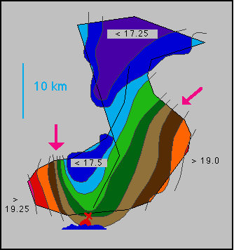 This figure shows the sea surface temperature derived from a ship survey. The
thin black line indicates the ship´s track. The buoy is seen at the bottom
of the frame; it is located approximately at the black dot of the previous
figure. Isotherms are drawn every 0.25°C.
This figure shows the sea surface temperature derived from a ship survey. The
thin black line indicates the ship´s track. The buoy is seen at the bottom
of the frame; it is located approximately at the black dot of the previous
figure. Isotherms are drawn every 0.25°C.The two arrows indicate the axis of the upwelling front. Note how the front is bent into a filament or extrusion of cold upwelled water into the open ocean.
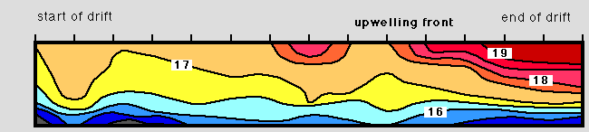
The last figure (below) is a temperature section along the path of the second drift. Note that the buoy followed the water movement, so the temperature should not change very much at all. The fact that the surface water became warmer very rapidly towards the end of the drift indicates that the buoy approached the front. This in turn is evidence for convergence in the frontal zone. Adapted from Tomczak (1973)