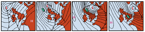
 Weather charts for 30/1 and 1/2/1953 when the major storm surge listed in the table occurred. The charts are 12 hours apart at (from left to right) 30/1 1200 UTC (986 hPa), 31/1 0000 UTC (970 hPa), 31/1 12 UTC (965 hPa) and 1/2 0000 UTC (972 hPa). Numbers in brackets give the pressure in the storm centre (the low pressure cell marked L) in hPa, and contours are 4 hPa apart.
As the storm intensifies during the 12 hours from 30/1 to 31/1 it passes northern Scotland and moves into the North Sea. The green arrows indicate the direction of water movement as the surge develops.
The storm surge shown in Figure 4.1 was produced by a similar system but was less severe than the storm shown here.
© 2000 M. Tomczak
contact address: