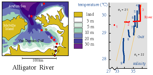
The Alligator River in the Northern Territory of Australia. Left: topography and station locations; right: temperature-salinity (TS-) diagram.
The salt plug is at station 3. Stations upriver from the salt plug are marked by black circles on the map and shown in red in the TS-diagram. Stations downstream from the salt plug are marked as red dots on the map and shown in blue in the TS-diagram.
Salinity and temperature are uniform and fresh at station 1. Station 2 shows some salinity stratification but uniform temperature. The salt plug (station 3) shows some temperature stratification in the upper layer and salinity stratification in the lower layer. Stations downstream from the salt plug display some temperature stratification but vertically mixed salinity conditions. The strength of the salt plug is clearly seen from the continuous salinity decrease between stations 4 and 9.
Adapted from Wolanski (1986).contact address: