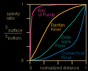
 The ratio of surface to bottom salinity Ssurface/Sbottom in positive estuaries as a function of normalised distance for different estuary types. x/L = 0 is at the head of the estuary, x/L = 1 at the mouth.
Interpretation of the diagram is straightforward. Positive estuaries all start with Ssurface/Sbottom = 0 at the head (where the fresh water enters at the surface) and end with Ssurface/Sbottom = 1 at the mouth (where, by definition, conditions are oceanic from surface to bottom). Between these two points, the vertically mixed estuary has identical surface and bottom salinities, its diagram follows the line Ssurface/Sbottom = 1. The Bay of Fundy comes very close to this situation. In the salt wedge estuary, surface salinity remains zero throughout, so its diagram follows the line Ssurface/Sbottom = 0. The highly stratified estuary is associated with small Ssurface/Sbottom values and found in the lower right; the Connecticut River gives an example. The slightly stratified estuary has higher Ssurface/Sbottom values; examples are the Delaware River and the Raritan River and Bay.
contact address: