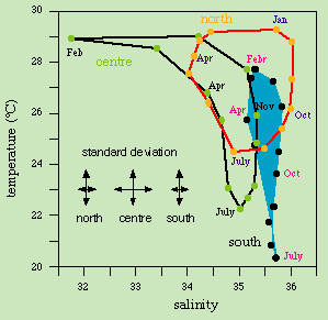
Water mass definitions (TS-time diagrams)
for the southern, central and northern regions of the Great
Barrier Reef lagoon. The regions are defined as north = 10
- 15°S, centre = 15 - 20°S,
south = 20 - 25°S. Standard
deviations are not given for every month but for the
ensemble of TS-data in each region. Adapted from
Pickard (1977).
© 1998 M. Tomczak
contact address: