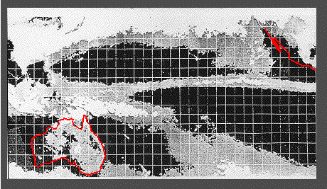
The Intertropical Convergence Zone (ITCZ) and the South Pacific Convergence Zone (SPCZ) as seen in satellite cloud images. The figure is a composite of many months of observations, which makes the cloud bands come out more clearly. High cloud density indicates condensation from rising air and thus high rainfall. The figure covers the region 40°S - 40°N, 97°E - 87°W; the grid gives every 5 degrees latitude and longitude (Australia is in the lower left, parts of North America with Baja California in the upper right). From Tomczak and Godfrey, Regional Oceanography: an Introduction, Pergamon, New York (1994), 422 pp.
contact address: