quotation continued
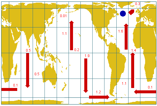
The above map shows how the ocean circulation distributes heat throughout
the world's oceans (In petawatts (PW), 1 PW = one billion megawatts). Some
essential ideas involved or demonstrated in this illustration (and not yet accepted in every detail by the scientific community) are:
- the atmosphere is driven by heat given off by the ocean;
- this heat is the major energy source for powering the strong westerlies in the North Atlantic (about 1 PW annually);
- the concentration of heat flow from the ocean to the westerlies in the vicinity of the blue dot (off the coast of Newfoundland) can be very much greater during "peak loads" than the 100 megawatts per square km average for the region;
- to supply that massive heat flow to the westerlies in the North Atlantic, the ocean circulation delivers heat from the Pacific and Indian Oceans;
- the arrows show the direction of heat flows in the global ocean; and
- the differences between the values shown at selected latitudes represent the heat (in PWs) contributed to the atmosphere from the ocean between those latitudes.
©
1996 M. Tomczak,
based on J. D. Woods, The upper ocean and air-sea
interaction in global climate; in J. T. Houghton (editor) The Global
Climate, Cambridge University Press 1984, pp. 141-187.
contact address: