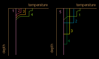
Development of the seasonal thermocline during the year.
Left: warming cycle. It starts with vertically homogeneous conditions (1). Heating at the surface warms the water; the heat is stirred into a mixed layer by wind mixing (2). This continues for several months (3). In mid-summer winds are often weaker than during spring, wind mixing does not reach quite so deep, and the mixed layer may consist of two or more homothermal layers (4).
Right: the cooling cycle. It starts at the end of summer (1, which is identical to 4 of the warming cycle). Cooling at the surface leads to instability and vertical overturn. This progressively deepens the mixed layer (2-4), until it disappears in winter (5).
Numbers can be approximately taken as successive months, with the following association:
| southern hemisphere | northern hemisphere | |||
| number in graph | warming cycle | cooling cycle | warming cycle | cooling cycle |
| 1 | August | December | February | June |
| 2 | October | February | April | August |
| 3 | November | March | May | September |
| 4 | December | April | June | October |
| 5 | July | January | ||
contact address: