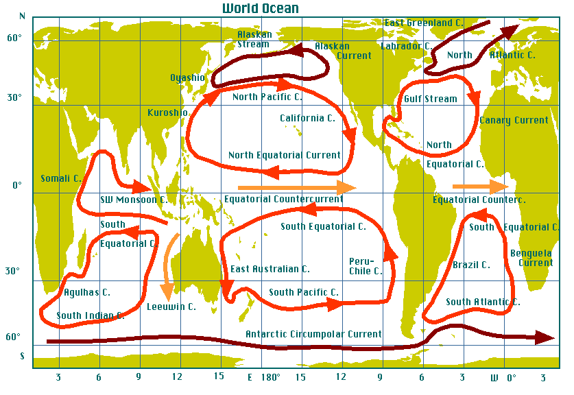
Surface currents of the world ocean.
Currents in the Indian Ocean are shown for September/October (Southwest
Monsoon season). The subtropical gyres are shown in orange, the subpolar gyres
and the equivalent current in the southern hemisphere in dark brown.
Tropical currents are shown in gold. Note that the figure does not indicate
the strength of the current; western boundary currents are much stronger
than all other currents.
The western boundary currents are:
| ocean basin | northern hemisphere | southern hemisphere |
| | subpolar gyre | subtropical gyre | subtropical gyre |
| Atlantic Ocean | Labrador Current | Gulf Stream (1) | Brazil Current |
| Pacific Ocean | Oyashio (2) | Kuroshio (3) | East Australian Current |
| Indian Ocean | | Somali Current | Agulhas Current (4) |
- (1) The name goes back to the early belief that the current along the east coast of Florida originates from the Gulf of Mexico as outflow from the Mississippi River and other tributaries. It is now known that the current traverses the Gulf, entering it through the Strait of Yucatan and leaving it through the Strait of Florida.
- (2) Japanese for "productive current" or "parent current", because the Oyashio carries cold water rich in upwelled nutrients and full of marine life.
- (3) Japanese for"black current", because the Kuroshio is low in nutrients and marine life, so its waters have the dark blue colour of unproductive ocean water.
- (4) After a headland and a gulf along the path of the current named the "Golfo das Agulhas" or "Gulf of Needles" by Portuguese explorers, because during the late 15th and early 16th century the magnetic declination in that region was zero, i.e. magnetic north and true north were identical at that location during that time and a compass needle therefore showed exactly true north.
©
1996 M. Tomczak
contact address: