Exercise 4: Water masses.
Page 13
|
The similarity of the TS-diagram between widely separate
stations indicates the presence of water masses. Water
masses are formed through interaction with the atmosphere
which - through rainfall and evaporation - influences the
salinity and - through heating and cooling - influences the
sea surface temperature.
| A water mass is a body of water with a common formation history. |
Water masses formed in
high rainfall areas are characterised by relatively low salinity,
water masses formed in polar regions by very low
temperatures etc
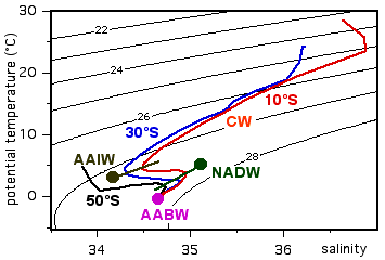
The convergence of all TS-curves towards one TS-point at
low temperatures indicates the presence of Antarctic Bottom
Water (AABW). This water mass is formed at the Antarctic
continent, where cool and saline surface water sinks down
the continental slope to the ocean floor. AABW spreads
northward from the Southern Ocean and fills all oceans
below about 4000 m depth.
|
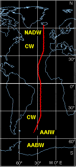
Water mass formation regions
|
The minima and maxima in the TS-diagram indicate the presence of two other
water masses.
Antarctic Intermediate Water
(AAIW)
is formed in the region of the southern hemisphere westerlies, where rainfall
is large, and therefore has low salinity. It sinks to about 1000 m depth and
moves northward in all oceans. In a TS-diagram it is seen as a salinity
minimum. The diagram above indicates AAIW as a dark circle. As this water moves
northward it mixes with the more saline water below and above. This increases
its salinity and shifts the salinity minimum towards higher salinity values,
along the dark line shown in the diagram.
The salinity maximum indicates the presence of
North Atlantic Deep Water
(NADW). This water mass is formed in the Greenland and Labrador Seas where it sinks
to about 3000 m depth and moves southward through the Atlantic Ocean,
eventually reaching the Southern Ocean and from there entering all other
oceans. The diagram above shows it as a green circle. Like AAIW, the NADW mixes
with the water below and above, which reduces its salinity as it progresses
southward and produces a southward decrease of the associated salinity maximum
along the green line shown in the diagram.
The water mass of the upper 1000 m, where temperature and salinity change
rapidly with depth along a well defined line in the TS-diagram, is known as
Central Water (CW). Each ocean has its own varieties of Central Water in both hemisperes, which we are not going to follow up here.
The next few pages study the distribution and pathways of some key water massses in data animations.
 © 2000 m. Tomczak
contact address:
home page: http://www.es.flinders.edu.au/~mattom
web address of Exercises in Oceanography: http://www.es.flinders.edu.au/~mattom/IntExerc
This page last updated 5 December 1999